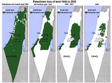
 Infographic of land-theft in Palestine
Infographics are popular these days, and I was surprised to see one about the occupation of Palestine featured in the Politics section of the GOOD official website. The graphic, titled “Cartographic Regression“, highlights Palestinian land-loss from 1917 until today.
My opinions on the graphic are mostly but not entirely favorable. I do appreciate GOOD’s attempt to visually show how Palestinians have been forced to deal with illegal land-theft and colonization for almost an entire century, but certain omissions, such as the de facto annexation of Palestinian land through the Apartheid Wall’s encroachment into the West Bank, leave me disappointed.
Nevertheless, if there is one thing to praise about this piece, it is the detail of the West Bank territory in the map of present-day Palestine. We are oftentimes made to believe that Palestinians maintain complete control over their respective territories, but in the West Bank, where illegal Israeli settlements continue to grow and military forces are deployed to systematically restrict freedom of movement for the indigenous Palestinian people, the area is broken into dozens of small zones that don’t necessarily feature full Palestinian autonomy. Entire roads crossing the West Bank, for example, are for “Israelis only”. This is one detail the graphic designer got right.


